There’s a lot of growth happening in Low Earth Orbit (LEO). Over the next 5–10 years, we expect at least an order of magnitude increase in the number of operational satellites to be launched. However, not all satellites are distributed evenly in LEO. Just as we have varying amounts of driving traffic on different roads (e.g. back country roads vs. interstates), there is a parallel here for space as well. Some orbits are more advantageous to be in than others for operational satellites, and are thus more crowded.
The most notable of these orbits is referred to as a Sun-Synchronous Orbit, or SSO. SSOs are unique in that they “lock” the satellite into a precession rate around the Earth that matches the Earth’s movement around the Sun. This precession is made possible by the fact that the Earth is not a perfect sphere, but rather an oblate spheroid that is wider at the equator than at the poles. Those familiar with orbital mechanics will be well familiar with this fact and the resulting J2 effects that must be taken into account when predicting the motion of orbiting objects. This orbital precession for SSOs requires inclinations typically between 96 and 100 degrees, depending on the chosen orbital altitude.
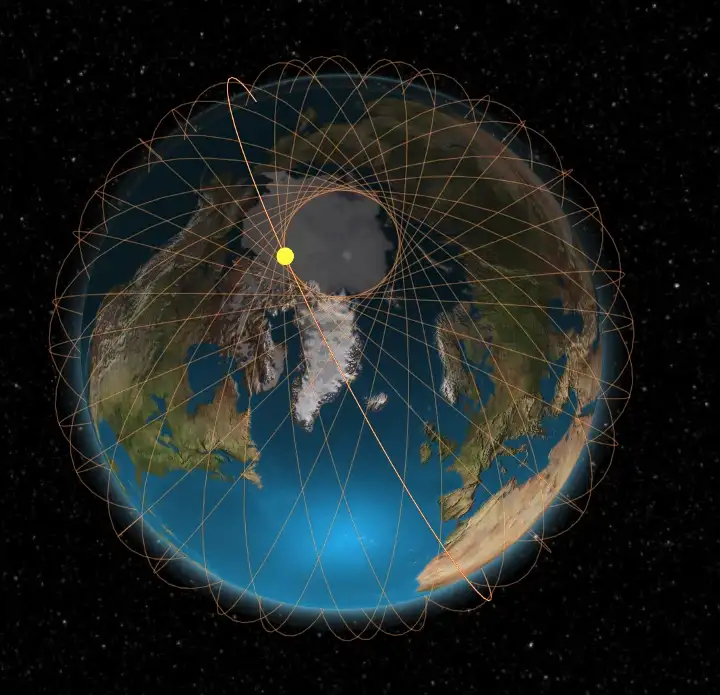
Orbital path of a satellite in example SSO (98 degree inclination at 700km altitude)
In practical terms, the benefit of using SSOs for many types of satellite missions is that the satellite will pass over the same area of Earth at approximately the same local time each day. This results in consistent lighting conditions from one orbit to the next, a highly useful benefit for multiple aspects of mission operations including solar power generation and Earth imaging applications.
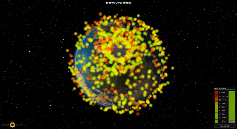
SSOs, and other high inclination polar orbits account for nearly 85% of all objects we track in the LeoLabs object catalog. This cumulative effect creates unique traffic hot spots near the North and South poles, and a visible near-empty ring of space that results from thousands of objects at high inclinations passing by one another.
When viewed from above, it has the appearance that the Earth has an orbital “bald spot” more than 1,000 km wide, surrounded by a ring of satellites corresponding to the inclination of most SSOs. Of course, this ring is not composed of satellites going around the pole itself, but is rather the superposition of many objects continuously passing within a few degrees from each pole. In mathematics this is known as a caustic, and is a familiar concept to anyone who has ever played with an old toy called a spirograph!
As you might expect, more crowded areas of traffic in space can lead to more potential collision events. Indeed, this is exactly what we see in our conjunction screening system — more close approaches are concentrated around the poles than anywhere else on Earth.
The 3D visualization below represents close approach events in LEO over the last 24 hours using LeoLabs’ object catalog. Each dot represents the crossing of two objects that pass within a few kilometers of each other; red dots represent the closest miss distances of a few hundred meters or less!