Short on time? Listen to this article on-the-go.

At 7.8 kilometers per second, it takes around 90 minutes for a satellite in low Earth orbit to complete its journey around the Earth. During that time, it passes over different countries, continents, oceans, and whole regions of our planet. Unfortunately, around half of that journey (i.e., 45 minutes) is somewhat of a mystery due to the lack of global radar coverage, particularly in the Southern Hemisphere.
The role of radars on Earth and in space
Recent news of “unidentified areal phenomenon” (UAPs) across the United States and Canada have sparked a sudden public interest in radars. With that in mind, we’d like to issue a reminder that beyond identifying UAPs, radars are also used for things that our daily lives rely on, like weather monitoring and air traffic control.
“At 7.8 kilometers per second, it takes around 90 minutes for a satellite in low Earth orbit to complete its journey around the Earth. Unfortunately, around half of that journey is somewhat of a mystery…”
You’ve likely boarded a plane in the middle of a rainstorm before and thought, “How can the pilots see through this? Won’t they hit something?!” Thankfully, this disaster scenario is extremely unlikely due to the breadth of radar coverage that exists on a global scale. From Primary Surveillance Radars (PSR) to Surface Movement Radars (SMR), governments have invested billions in gaining a comprehensive, continuous view of the sky and the ground to ensure air traffic safety. If a plane is approaching another plane or flying into severe weather, these radars provide the necessary data to pilots and air traffic controllers to keep passengers safe.
A similar system is needed for space.
As the traffic in LEO grows, so does the need for space safety and Space Domain Awareness (SDA), which requires comprehensive, continuous coverage of the space environment. In particular, we need to reduce the time elapsed between observations (i.e., the revisit rate) in order to study and monitor activities in space, from potential collisions and satellite maneuvers to proximity operations and anti-satellite weapon tests. This requires not only increasing the number of ground radars intended for space observation but also distributing them geographically. In fact, doing so in the Southern Hemisphere is increasingly important. Here’s why.
The gaps in coverage of the Southern Hemisphere
For most of the Space Age, the identification and tracking of objects in LEO has been a service provided primarily by the US Space Surveillance Network (SSN). This Network, initiated in the 1960s, utilizes a variety of sources for its observation data, including radar, optical, radio, and visual. When first conceived during the Cold War, the Network’s primary mission was to help protect North America from missile strikes and other adversarial activities coming over the North Pole. To complete that mission, the US Government built radars largely in the Northern Hemisphere, across North America and Europe. That national security and geopolitical reality left large swaths of the globe uncovered, with only one radar located in the Southern Hemisphere.
Historically, most of the radars that have been designed to track space objects are decades-old ballistic missile warning radars that only track satellites when not performing their primary mission. In today’s dynamic space environment, however, a dedicated, modern, and more geographically distributed radar network is needed.
More coverage is critical to Space Domain Awareness
Of course, a lot has changed since the 1960’s and the end of the Cold War. Not only has commercial space exploded in the last few decades, but the number of nations with space programs has also increased dramatically.
At the start of the Space Age, there were two primary actors in space: the United States and Russia (formerly the USSR). Today, 13 countries, including the European Union, have proven orbital launch capabilities — around 90 countries have objects in space. Countries in the Southern Hemisphere, specifically the Indo-Pacific region, are increasingly launching their own satellites into LEO for a variety of civilian and military purposes.
“Countries in the Southern Hemisphere, specifically the Indo-Pacific region, are increasingly launching their own satellites into LEO for a variety of civilian and military purposes.”
In addition to decreasing revisit rates, reducing the time it takes to identify and track newly launched satellites is also important for both space safety and SDA purposes. Newly launched payloads “go in all sorts of different trajectories,” explained LeoLabs CEO Dan Ceperley in a recent interview with Breaking Defense, “so having another radar in another location will pick them up sooner.” Without sufficient coverage, satellite owner-operators, government regulators, national defense agencies, and other stakeholders are left in the dark for at least half of that space asset’s lifetime — this uncertainty and lack of clarity brings risk.
Recent examples illustrate the critical need for Southern Coverage
As previously mentioned, to strengthen Space Domain Awareness, we must reduce revisit rates. By building more space surveillance radars, especially in the Southern Hemisphere, we’ll do just that.
Based on preliminary research, we found that by adding the LeoLabs Kiwi Space Radar (KSR) located in New Zealand (operational since 2019) and the West Australian Space Radar (WASR) located in Western Australia (operational since late 2023) to LeoLabs global radar network and to the SSN, we will reduce revisit rates. We’ve found that for the majority of cases, we can reduce revisit rates for a subset of high interest objects by 35% (for the 70th percentile; 119 minutes to 51 minutes). By adding more radars in the Southern Hemisphere in 2024, we estimate that we’ll be able to reduce that even further.
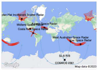
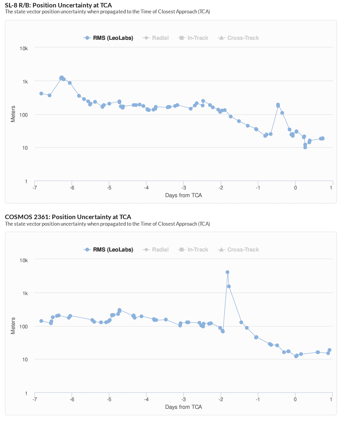
Our radar sites in the Southern Hemisphere — equipped with S-band technology — provide convenient observations for conjunction events at very low latitudes. This results in more accurate assessments of conjunctions in the region. A recent close approach just over Antarctica between a derelict SL-8 rocket body and a Cosmos spacecraft illustrates the typical event that we can characterize effectively due to this coverage.
The two graphs below illustrate the state vector position uncertainty of both objects over time prior to the conjunction. As the Time of Closest Approach (TCA) drew closer, our system was able to reduce the position uncertainty to just tens of meters (usually, an operator would likely act on 100 meters). This is largely the result of two factors: 1) the two objects’ orbital stability and 2) our radar coverage. We were able to calculate such low position uncertainty due to the coverage from our two radar sites in the Southern Hemisphere.
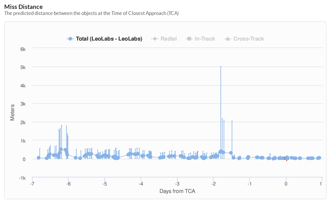
The graph below illustrates the “miss distance” of the two derelict objects. The relatively flat line over time indicates that our radar coverage in the Southern Hemisphere provided consistent and reliable measurements of the objects’ relative position. As a result of the state vector updates closer to TCA due to our radars in the region, the probability of collision (Pc) value provided by LeoLabs (Pc ~2.3e-2) differed from the SSN’s Pc value largely based on the more recent state vector update provided by our radars. (The 19th Space Defense Squadron calculated a Pc about 100 times smaller based on less current radar measurements and different hard body radius estimates.)
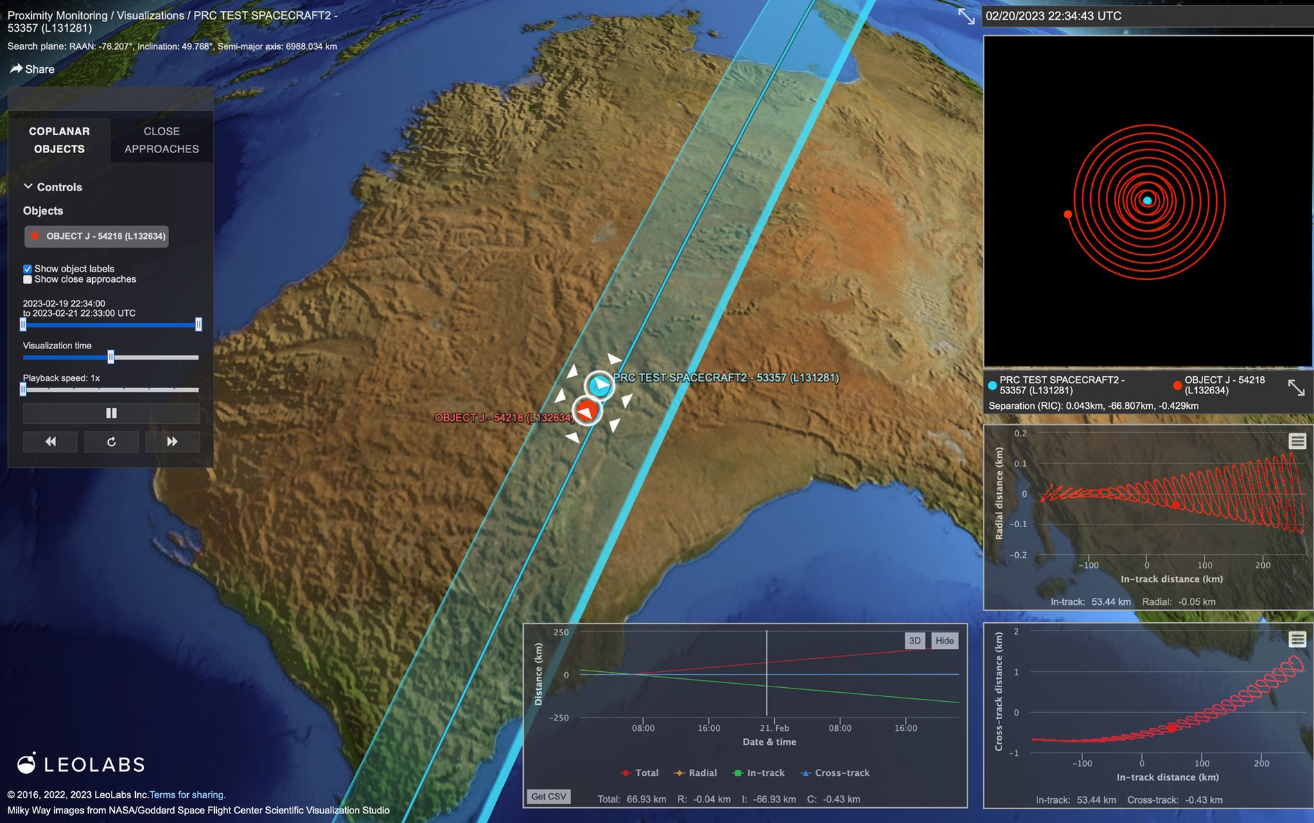
In addition to the SL-8/Cosmos event, our team was notified on Monday, 20 February about activity regarding the PRC Test Spacecraft2 (NORAD ID: 53357). Data we received from KSR indicated that the spacecraft had recently deployed a payload for unknown purposes. (See the image below.) In the 24 hours immediately following the activity, we received more than 10 radar passes for both objects thanks to the coverage provided by both KSR and WASR. Although the purpose of this activity is still unknown, we were able to determine the orbits and relative behaviors of both spacecraft and have continued to monitor this activity through our in-house tools.
The solution? Build more radars.
The two events outlined above affirm our reasoning behind building additional radars globally: more coverage means more clarity. Our aim is to continue to increase this coverage, not only of the Southern Hemisphere, but also of the Northern Hemisphere and equatorial regions. In fact, we’d be remiss to not point out briefly the importance of more radars in the Northern Hemisphere. Due to the limited number of radars in this region, an object’s orbit needs to be aligned just right to receive quality measurements. Put simply, we need to build more radars globally to reduce the time between observations and update an object’s state vector more often.
“Our aim is to continue to increase this coverage, not only of the Southern Hemisphere, but also of the Northern Hemisphere and equatorial regions.”
Existing gaps in global coverage of LEO are not only a threat to space safety but also space security as they provide opportunities for adversaries to maneuver and become “lost.” Commercial radar networks that are equipped with the latest technology and dedicated to space tracking and surveillance are key to closing this gap. While the US Space Surveillance Network has served us well for decades it needs to be augmented with reliable, all-weather radars to secure low Earth orbit — a domain that’s become critical to our daily lives.
More of a visual learner? We’ve got you covered. Download this infographic.

And that’s all for now folks!
Stay tuned for the 6th edition of LeoPulse coming out in mid-March which will feature a thought leadership piece from our team. If you haven’t signed up for our newsletter yet, please do so you don’t miss the next edition. Want more content like this right now? Check out the previous editions of LeoPulse. We suggest starting with LeoLabs CEO Dan Ceperley’s guide to potential disasters in LEO.
Ad astra!
Note: The findings shared in this report and infographic are derived from the hundreds of thousands of data products LeoLabs’ global network of phased array radars collects daily.